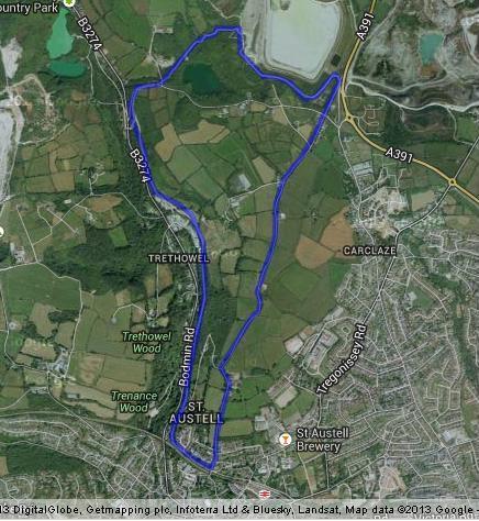
Carclaze loop
Directions and points of interest
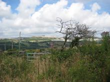
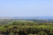
This circular route is an amended and extended version of the St Austell circular more suited to cyclists than walkers and will really blow away the cobwebs taking you up to the top of one of the highest hills overlooking St Austell Bay. Get up above the town and look out across the beautiful blue water to the day marker at Gribbin Head and maybe you'll even catch a glimpse of Fowey harbour over the headland.
Starting from Tremena Gardens head out towards the junction with Mennacuddle Hill. Take a left and carry on up Mennacuddle Hill until you cross over Drummers Hill and continue up Mount Stamper Road. Keep an eye out on the left-hand side and you will see a litter bin and a small path. Take the path and follow it round to the left. You will find yourself on National Cycle Route Two, on a wide stony trail.
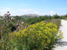
Follow this downhill for about a quarter of a mile and take the first left hand fork that you come to. Take the next sharp left and follow the trail down the steep hill. Keep an eye out on the left side of the trail for an open grassy area with a fence all round; it's the ideal spot for a rest or even a picnic. Continue on the trail down the hill to a gate. Take care with children as there is a road crossing. Cross over into the trail and continue on the easy tarmac. After another quarter of a mile there is another fork. Bear left and keep on the trail for another mile and a half. Keep and eye out for a Carlyon Farm Kiln, a large ruined china clay drier on the left of the path.
You will come to a gate across a tarmac driveway. Cross over the small road whilst bearing left and cycle to the left of the wooden bollards. Follow the trail round to the left for about 100 yards until you emerge into Tremeena Gardens back where you started.
Extending the route
Extend the route to Eden Project by following the Wheal Martyn to Eden Project trail.
Facilities and attractions
Facilities:
St Austell rail station
cafe, toilets
Attractions:
St Austell Brewery
Take a tour around one of Cornwall's largest independent breweries
Suitable for:
- Walking
- Cycling
Distance:
4.2 miles (6.8km)
Terrain:
Cycling grade:
Highlights:
- Beautiful views of St Austell bay
- Take advantage of a loop comprising of two clay trails